Basic HTML Version


Iowa’s County Conservation System
211
ACREAGE
CAMPSITES:
E
lectric/
F
ull Hookup/
N
on-Electric
Eq
uestrian/
Y
outh/
D
ump Station/
W
iFi
WATER:
D
rinking/
S
howers
TOILETS:
F
lush/
V
ault
CABIN RENTAL:
S
easonal/
Y
ear Round
SHELTER:
E
nclosed/
O
pen/
F
ree/
R
ental
P
ICNICKING
TRAILS:
B
ike-Hard Surface/
L
imestone/
M
t.Bike/
W
ater
E
questrian/
H
iking/
S
nowmobile/
X
C Ski-
G
roomed
SWIMMING:
B
each/
P
ool
FISHING:
J
etty/
P
ier/
L
ake(acres)/
S
tream or River/
T
rout
BOATING:
C
anoe/
E
lectric/
M
otor/
BR
-Boat Rental/
R
amp
SPORTS:
A
rchery/
B
aseball/
D
isk Golf/
G
olf/
H
orseshoe
I
ce Skating/
P
layground/
S
hooting Range/
Sl
edding
T
ennis/
W
inter Sports
SITES:
A
mphitheater/
Ar
boretum/
B
ird Watching
Wildlife
E
xhibit/
H
istoric Site/
N
ature Center
P
rairie/
W
etland/
Wo
odland
HUNTING:
F
orest/
U
pland/
W
etland
County
ACREA
CAMPSITES: lectric/ on-Electric/ ull Hookup,
E
N
F
outh, ump Station/ iFi, uestrian
Y
D
W Eq
WATER: ri king/ howers
D
S
TOILETS: lush/ ault
F
V
CABIN RENTAL: easonal/ ear Round
S
Y
SHELTER: nclosed/ pen/ ental/ ree
E
O
R
F
ICNICKING
P
TRAILS: iking/ questrian/ ike-Hard Surface/ t.Bike
H
E
B
M
/Bike- imestone/ nowmobile/ C Ski- roomed/ ater
L
S
X
G
W
SWIM IN : each/ ool
B
P
FISHING: ier/ etty/ ake(acres)/ tream or River
P
J
L
S
B ATING: otor/ anoe/ lectric/ -Boat Rental/ amp
M
C
E
BR
R
SPORTS: rchery/ aseball/ olf/ inter Sports/
A
B
G W
layground/ hooting Range/ orseshoe/ ennis/
P
S
H
T
ce Skati g/ edding/ isc Golf
I
Sl
D
SIT S: ature Center/ istoric Site/ rairie/
N
H
P
Wildlife xhibit/ etland Area/ mphitheater
E
W
A
ird Watching/ odland/ boretum
B
Wo
Ar
HUNTING: etland/ orest/ pland
W
F
U
1. Becker Wildlife Area
1 mi. N of Ft. Dodge
8
S
C
P4, B, Wo
2. Bob Hay Memorial Conservation
Area
1 mi. W of Hwy 169 on Rich Mill
Road
225
L1, S
P20, B, Wo W,
F, U
3. Carlson Recreation Area
6 mi. SE of Dayton/ 2 mi. S of Hwy.
175 on River Rd
120
S
C
W1, P12,
B, Wo
F
4. Cunningham Access
5 mi. NW of Ft. Dodge on Hayes
Ave.
0.5
S
C
5. Deer Creek Area
8 mi. N of Ft. Dodge, E of Hwy 169
on 130th St
17
S
M, C
B, Wo
F, U
6. Holiday Creek Area
3 mi. SE of Ft. Dodge on Hwy. 20
38
S
B, Wo
F
7. Kennedy Memorial Park
4.5 mi. N of Ft. Dodge on Hwy. 413
400 E41,
N10,
F29,
Y1, D,
W
D, S F*,
V
S1
ER1,
OF6*
P H4, X4
B J, L45 C, E,
R
B, G, W, P, I,
Sl, H
N, E, A,
P15, B,
Wo, Ar
8. Lentsch Access
7 mi. NW of Ft. Dodge on P29
0.5
S
C
9. Lindquist Wildlife Sanctuary
Gowrie
6
H.5
W1, B, Wo
10. Liska-Stanek Prairie
6 mi. SW of Ft. Dodge
20
H, W1,
P19, B
U
11. Lundgren Church Nature Park
8 mi. S of Ft. Dodge
1
P
B, Wo
12. Meier Memorial Marsh
6 mi. NW of Barnum
35
S
W2, P30, B W, U
13. Miller Marsh
1 mi. N of Vincent
185
W60, P125,
B
W, U
14. Moorland Pond
1 mi. E of Moorland
23
L15
C, E
P7, B
15. Prairie Pond Wildlife Area
2 mi. S of Duncombe
17
L12
C, E
P, B
16. Rasch Access
3 mi. NW of Ft. Dodge on Hayes
Ave.
0.5
S
C
17. Rossow Prairie
5 mi. N of Duncombe
40
W12, P28,
B
W, U
18. Skillet Creek Indian Mounds
3 mi. E of Dayton on Skillet Creek
Ave.
18.5
H1.0
H, B, Wo
19. The Diggings
NW Fort Dodge
7
H.5
H, W, B
20. Whispering Wings
2 mi. E of Fort Dodge
20
W2, P18, B W, U
* Handicap Accessible
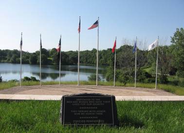
Veteran’s Memorial Park at Kennedy Park
overlooking Badger Lake.
Webster