Basic HTML Version


Using your Outdoor Guide …….
(SAMPLE)
FACILITY &
ACTIVITY
GRIDS
(SAMPLE)
COUNTY CONTACT INFO.
(Phone, email, mailing address, hours, etc.)
COUNTY LOCATION ON STATE MAP OF IOWA
LEDGEND ITEMS ON MAPS
-
County Facility
–
green areas with associated area number
1 8
-
Trails
–
major “stand alone” trails, connecting areas, towns & counties
-
Highways
–
arterial main highways and interstates with numbers
-
Roads
–
generally local roadways – may be gravel or local highways
-
Water Trail
–
Area rivers, streams & lakes with developed water trails
-
Rivers/Lakes
–
creeks, streams, rivers and lakes within each county
-
City/Town Limits
– designates approx. boundaries for towns & cities.
Q.R. CODES
–
with a free downloaded app to your cell phone, scanning these
Q.R. codes will take you to the individual home page for that county, located on
our statewide website at:
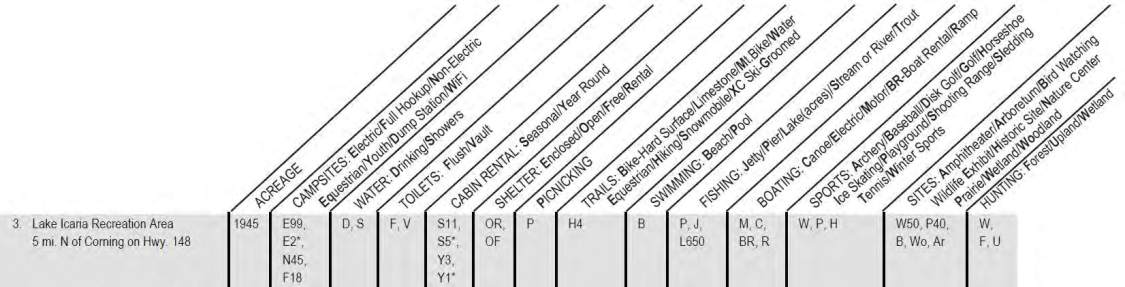
AREA NUMBER
corresponds to matching number on adjacent map
3
ACREAGE
refers to the total acres for that particular area
BOLDED LETTERS
on the front of certain significant words indicate the availability of that facility or activity in that particular area.
- CAMPSITES –
E
lectric = # of electrical camping sites in this area; E2* = # of those electric sites which are handicapped accessible.
- CABIN RENTAL
–
S
easonal = # of seasonal cabins in this area; S5* = # of those seasonal cabins which are handicapped accessible.
- TRAILS
–
H
iking = hiking trails available in this area; H4 = 4 miles of hiking trails available at this area.
- FISHING
–
L
ake = Lake fishing available; L650 = 650 acres of lake fishing available at this area.
ASTERI
S
K
– an Asterisk (*) following any symbol indicates handicapped accessibility for that type of facility in that area.
Please utilize our website at
for additional information about each county, or feel
free to contact the individual county directly via the contact phone number, email or mailing address provided.